
The Leh Manali Highway is one of the most picturesque and talked about highways that connect Leh in Ladakh, to Manali in Himachal Pradesh. Furthermore, it connects Manali- Solang Valley to Lahaul and Spiti Valleys in Himachal to Zanskar Valley in Ladakh. Flanked by high Himalayan and Karakoram mountain ranges, the route is open only for less than five months in a year and is trodden upon by enthused motorcyclists.
The Rohtang Pass Tunnel, also known as the Atal Tunnel, was opened on the 3rd of October 2020 and has reduced the length of the Leh-Manali Highway from 470 km to 430km. This reduces the travel time over the highway by over 3.5 hours and the entire journey can be completed in under 14 hours.
Leh Manali Highway- An Adventurous Route
The general route that the Leh-Manali highway follows is as follows:
Day 1:
Manali – Rohtang La Pass - Kokhsar – Tandi – Keylong – Jispa – Darcha – Deepak Tal - Sumdo – Patseu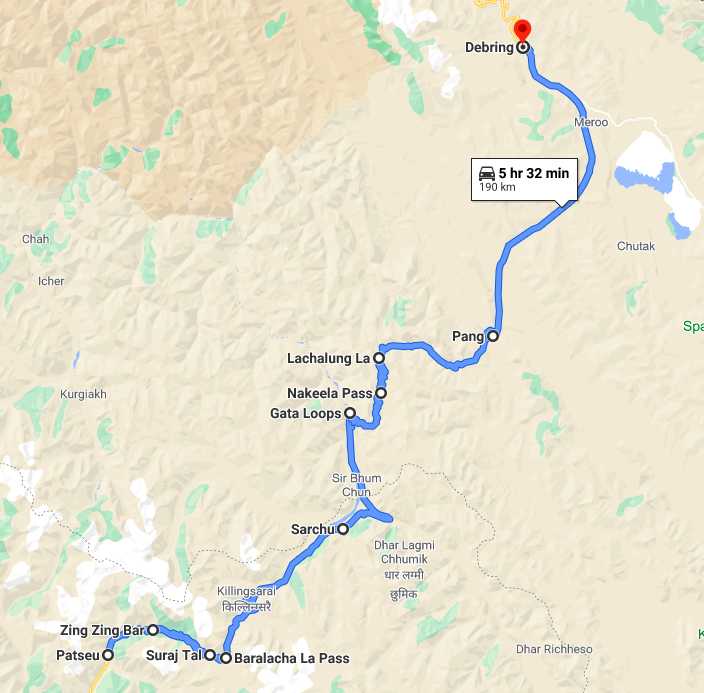 You would start your trip from Manali which is at an altitude of 1950m and travels up towards Rohtang La, situated at an altitude of 3980m. You’ll be passing Solang valley and Marhi on your way and covering 51 km in total. From Rohtang valley, you’ll be taking a downward slope, crossing through Kokhsar and Tandi (average altitude will be 2500m).
After Tandi, an upward journey to Baralacha La through Kelong and Jispa will get you to a height of 4890m. You’ll be crossing Kelong, Jispa, Darcha, Deepak Tal, reaching Patseo at the end of the first day.
Day 2:
Patseu - Zingzing Bar – Suraj Tal -Baralacha La – Sarchu – Gata Loops – Sarchu - Nakeela La – Lachulung La – Pang – Debring
After crossing Zingzing Bar and Suraj Tal, the second-highest lake in India travelers head on up to the Baralacha pass, you start your descent towards Gata Loops (4190m). You’ll pass through Sarchu on this leg.
It is one of the preferred locations for a night's stay. If you’re prone to AMS (acute mountain sickness), spend the night at Kelong or Jispa instead of Sarchu. Their lower altitudes will help you get dodge mountain sickness, and you can start early to cover the remaining distance in time.
Gata Loops are famous for the 21 hairpin bends that push you from 4190m to 4630m via a 7 km stretch. From there you continue your ascent towards Nakee La, situated at an altitude of 4740m. There are no facilities or habitats in this area. Next stop from Nakee la is Lachulung la. You will now enter the second highest pass on the highway, sitting at an altitude of 5079m.
Breathlessness, headaches, nausea, and uneasiness are common symptoms. Acclimatization to higher altitudes takes time. Avoid any exertion that might affect your breathing process. A downward drive from Lachulung pass takes you to Pang (4600m). From here, you’ll encounter plains till Debring (4835m). They are called the Moore plains

Day 3:
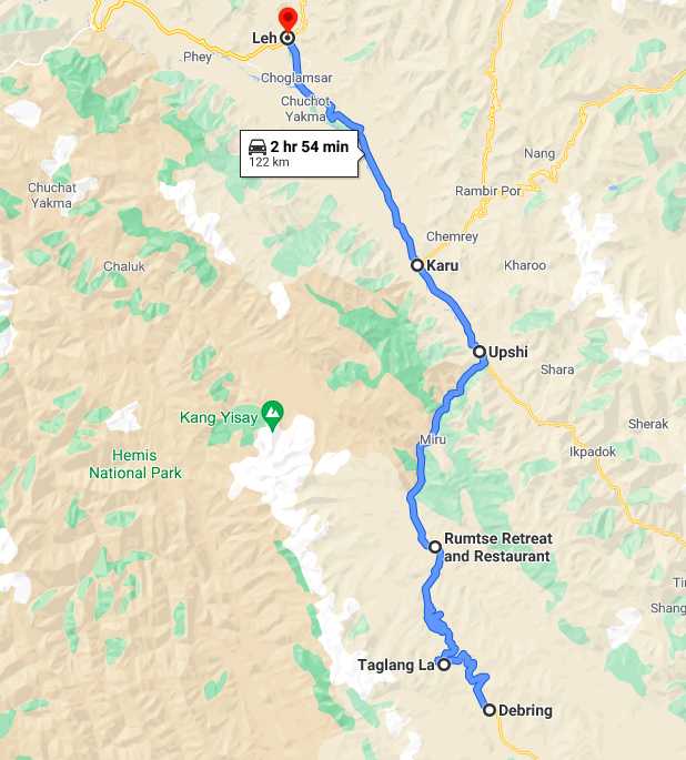
Debring – Tanglang La – Rumste – Upshi – Karu – Leh
Debring to Taglang is a steep ascent, covering 14.2 km. Taglang pass is the highest point on the highway, situated at an altitude of 5328m. Avoid stopping here for any more than 10-15 mins; high altitude can make you feel nauseous. From here, you begin your last and final descent towards Leh which is located at an altitude of 3500 m.
You will pass Rumste and Upshi on your way and reach Leh, covering 108.1 km. By the time you reach Leh, you’ll be acclimatized to higher altitudes and will find Leh very pleasing.
Travel Time on Manali Leh Highway
Depending on how long you plan to stay on the Leh-Manali Highway you want to stay for you can choose to cover the highway in one, two, or three days.- If you want to finish the journey in one day, consider factors like acclimatization, motion sickness, exhaustion (you’ll be on the road for a minimum of 16 hours), accidents like puncture or engine breakdown, and most importantly, the joy of missing out on some beautiful views. The chances of succumbing to ACM run high. Since you’ll be traveling through different altitudes without many breaks, it will eventually take a toll on your body.
- The two-day journey is the most preferred by routine as well as first-time travelers. This gives you enough time for acclimatization and unplanned stopovers. You can start from Manali, early in the morning, on day 1. Spend the night at either Keylong, Jispa, or Saracho. Technically, Sarchu is the middle point between Manali and Leh, but its high altitude is not suitable for everyone. Compared to it, Keylong and Jispa are much better. Start your second day early to arrive at Leh by evening.
- The three-day trip is the least preferred option due to time and cost. Two layovers will cost you extra money and time. From the experience point of view, it is more appealing as you can enjoy more places without rushing. You can begin your journey from Manali and reach Kelong/Jispa by evening.
Where to Stay on the Leh Manali Highway?
There are multitudes of places where you can stay to break your journey and rest for a while, while on the Leh Manali Highway.
2. Khoksar
2. Sissu
4. Gondla
5. Tandi
6. Keylong
7. Jispa
8. Darcha
9. Patseo
10. Zingzing Bar
11. Bharatpur
12. Sarchu
13. Pang
14. Upshi
15. Leh
Road Conditions
Conditions are subject to weather and season. Although the majority of the sections are safe and well-patched, there are some bumpy sections you have to look out for.
Smooth: Sissu to Keylong, Keylong to Jispa, Jispa to Zingzingnar, Zingzingbar to Baralacha pass, Moore Plains to Tanglang La pass, Tanglang pass to Rumste, Rumste to Leh.
Roads to look out for: Rohtang to Kokhsar, Baralacha pass to Sarchu, Sarchu to Pang, Pang to Moore Plains.
Average: Manali to Rohtang pass, Kokhsar to Sissu.
Best Time to Travel on the Leh-Manali Highway
Rohtang Pass and Baralacha Pass are open by May end. You can plan your trip from June onwards. You can see the stacks of snow from the previous winter season, and that’s why tourists most prefer this time of the year. By the time July hits, the snow starts to melt, and it becomes difficult to navigate through the freshwater passages. July onwards chances of rainfall are high. Although areas north of Keylong rarely see any rain, if you want to avoid any clashes, hit the highway in the August-September slot. September is the last month for a safe visit.
Passes on the Leh-Manali Highway
1. Tanglang La
Tanglang La Welcome to the highest point of your journey Tanglang La, the mountain pass with its top at over 5300 m. It provides a scenic view that you could not forget for life. Don't forget to take your cameras and handy cams during your trip because this high motorable pass will offer you incredible views to capture.
2. Lachulung La
Now be ready to pass the circular and long, the Lachulung La pass, which was the second pass of the Leh-Manali route. Although, if you have a problem with altitude sickness, then you might face a bit problem of breathlessness during the climb. It is one of the favorite passes of trekking and hiking enthusiasts. The tourist buses and taxis take time to halt to let the travelers admire the lovely views while crossing this pass.
3. Nakee La
The third pass of your journey Nakee la pass is at a height of 4750 meters. By the time you will reach the third pass of your trip, you will surely spell bounded by the glimpse of the Indus River flowing below. You must be genuinely cautious with the wheels on account of terrible street conditions that could test the patience of even the most experienced drivers. Sometimes heavy rains and snowfalls might block some parts of the roads, as the weather in this zone is unpredictable.
4. Baralacha La
It is one of the high mountain passes in Zanskar range, and it serves as a connecting point between Lahaul and Ladakh. The source of Bhaga River, Suraj Tal Lake is situated just a few kilometres from the pass towards Manali. It would be a bonus view of your journey.
5. Rohtang Pass
The Rohtang Pass is open from June to October for vehicles and one of the best times to visit Rohtang pass is from May/June to October/November. It becomes the hot spot for tourists, travelers, as they can opt for many exciting and adventure activities like skiing, mountain biking, snow scooter, and paragliding.
Important Tips For The Leh-Manali Highway Journey
- Don't be overconfident or overexcited during your trip as it is your biggest enemy.
- Before you all set to travel make sure you are physically and mentally fit and ready to face the challenges during the trip.
- Make sure you have your first-aid kit and all essential medicines with you.
- Make sure you have all the toiletries like toothpaste, toothbrush, soap, and sunscreen
- Carry an extra pair of warm shoes; don't wear sandals and slippers during your journey as it is freezing out there.
- Carry warm clothes, thermal liners, rain clothes and rain covers for your bags as be ready to experience bone-chilling cold.
- Be sure that you have enough amount of high energy food in stock, carry glucose, chocolates, and other energy food.
- If you are in your own vehicle, then make sure you have enough amount of fuel.
So, when are you planning your road trip on Leh-Manali Highway? Let us know in the comments below!