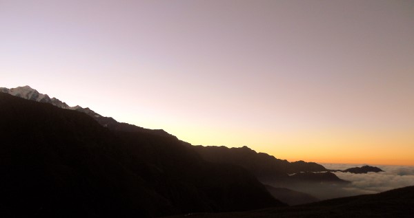
Beginners love the Roopkund Trek. The easy ascents, alpine trails, lovely twin meadows – Ali and Bedni Bugyal – and the view from the Junargali peak make it a highly rewarding one. Hear all about it from Keerthy, who went to Roopkund in September.
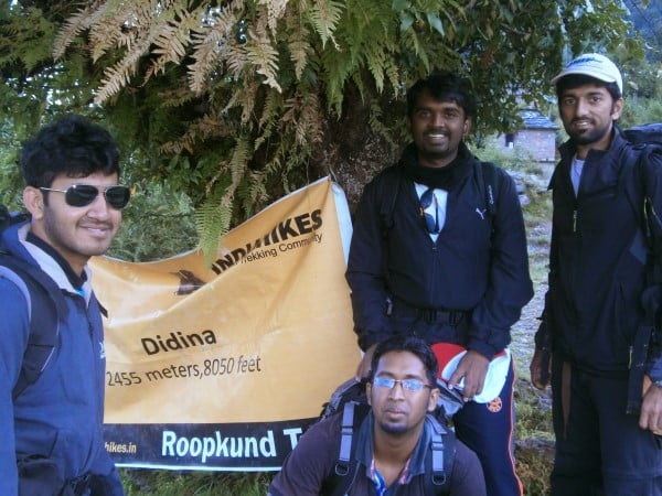
Day 1 – Lohjung to Didina
It was a bright and sunny morning. The day started at 5:45 am. No bath; only brushing and washing up, followed by a hot cup of tea. We had a session about how to efficiently pack stuff for treks – a comprehensive demonstration that lasted one full hour. Then we were asked to do the same in 30 minutes!
We finally finished packing only at 8:15, came down, and ate a quick breakfast. Roll call and the trek began at 8:45 sharp.
An average slope descent for almost 35 minutes, then it was more of slight ascent and slight descent. Overlooking another mountain where the destination Didina is located. We crossed couple of small bridges, couple of waterfalls. After 105 minutes of the trek, the first short-break overlooking the village of Kuling.
Another hour of descent later, we crossed the Neelganga river over an iron bridge. This is where we touch the other mountain that hosts Didina. The descent was fun but the real trek had just begun. The point where we cross the iron bridge is roughly at around 6,000 feet. Mild showers somewhat decreased the heat but the ascent and the sun turned out to be a deadly combination. So the break frequency increased
exponentially. Every 50 feet of ascent people stopped. We crossed a couple of small water streams en-route Didina. All in all, a good first day ended at 2pm approximately.
The first set of trekkers arrived at 1:35pm. The last trekkers arrived at 2pm. We trekked close to five hours on the first day.
Once we got to Didina, there were surprises after surprises. We got a welcome drink. (some juice made of local leaves). This was immediately followed by Kadi chawal andBhindi sabzee – an awesome combination.
Folklore:
There are two stories behind the name Didina. Firstly, the locals of this area felt that they were too far and isolated from the district of Wan, to which they originally belonged. So it’s like saying “De Dena” in Hindi which translates to “give it.”
The second story is a mythological one. Lord Shiva was in deep penance in this very area and Devi Parvathi was traveling through this area and happened to lose a jewel box on her way. Locals of this area prayed to Lord Shiva and requested him to find the lost jewel box using his special powers and return it back to Devi Parvathi. Again, they said “De dena” which turned out as “Didina.”
Didina Schooling and Education:
Didina has schools till 8th grade. Beyond that, the locals need to go to Wan. They grow rajma, potatoes and wheat for their livelihood. Many locals are into trekking organisations for their livelihood.
The team at Didina
Day 2: Didina to Bedini Bugiyal
(2,400mts/8,000 ft to 3,570m/11,700ft)
Undoubtedly, this is one of the toughest days of the trek. We had to cover almost 3,700 feet. The day began pretty early. We all received wake up calls by 5am. After the big first day, people woke up cursing, but everyone knew the earlier we left, the better for us. After a quick tea at 5.30am, people got ready and had an early breakfast at 7am. So by 7.30am, we started the ascent. As usual, Kundan chaacha lead us. It
was a steep ascent indeed. Thanks to weather gods no sun and no rain!
It was just perfect. The first break we took was after 45 minutes and it was not bad, as we had covered a good 700 feet. Even though we were scaling good heights in short time periods, the cloudy weather ensured that we were not dehydrated. The trail was pretty much through dense Himalayan forests with tall trees that ensured not much sun penetration. Everyone was pleasantly surprised when we realised that we had scaled up 2,000 feet in first two hours. This lifted our spirits. We kept climbing, taking small breaks and by 12 noon, we had scaled up enough for the day and we were very much in the vicinity of the Ali Bugiyal (Bugiyal means meadow). There are two meadows, namely Ali Bugiyal and Bedini Bugiyal, spread over 3,000 hectares. The forests opened up to beautiful lush green meadows. The biggest meadows we had ever seen in our lives.
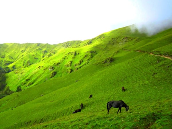
Beautiful meadows
There were no more steep slopes. Now, there were alternating small high/low slopes all along the trail. En-route to Bedini bugiyal from Ali Bugiyal, an interesting place welcomed us – A small shrine that had an 80kg stone. This stone was supposedly carried by a Singh from Tibet. All of us tried to lift it, but couldn’t lift it more than 1-2 cm from the ground. Finally, Mr. Machoman, our trek lead, Saranbir Singh, lifted it to his chest and threw it down!
Some entertainment, a good cold glass of Rasna and we left to Bedini. It was pretty much descent, with small ascents till we reached the camp site. The big day ended at 3.45 pm. Every one reached for a warm cup of coffee. Then a small acclimatization walk in the evening followed by hot dinner and we entered our tents.
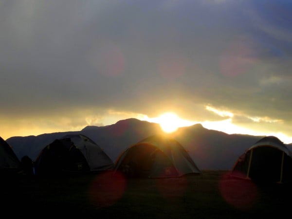
Campsite
Day 3 – Bedni Bugyal to Pathar Nachauni
Ali Bugyal and Bedini Bugyal are twin meadows at a height of 11,700 ft. This was yet another short stretch. The trek leader had informed upfront that it would be a small trek today. It was a relaxed day. We all woke up by 6.30 am and breakfast was served by 7.30 am. We all left to Pathar Nachauni by 8:15 approximately. Kundan chachagathered all of us near our first breakpoint i.e. Bedini Kund, a big calm serene lake with ultra transparent water.
Bedni
He briefed us about the temples, their historic importance and again we started ascending the slopes towards Pathar Nachauni. Today’s was mere 800 ft height gain so not much ascent, but more of flat trail walks with mild ups and downs.
We stopped at another point, where Kundan chacha explained the entire epic associated with Roopkund and we started gradually descending towards the Pathar Nachauni camp site. We were there by 1pm – perfect time for a big fat lunch.
Folklore:
Bedni Kund: Ved-ni Kund. This place has shrines of Laadu Devta and Maa Rajrajeshwari. We could view two snow clad peaks from here: Nanda Gomti and Trishul. It is called Panchganga, as it has 5 sources of water. It is also called Bramhataal.
Day 4 – Pathar Nachauni to Bhagwabaasa
Supposedly, this was yet another easy day, with just four hours of trek, as promised by the trek lead. We started at around 8:30 am and Kundan chacha ensured that everyone stuck to their group and he kept deliberately decreasing the speed as there was no point of reaching Bhagwabhaasa camp before 1pm. The group that was one day ahead of us was supposed to reach Bhagwabaasa camp after summitting, have lunch at Bhaagwabasa camp and make space for us. So, there was no point in reaching before they left.
Pathar Nachuni
All of us kept a rather slow pace. It was an ascent of around 2,000 ft today. Many a time, the ascent was steep. After about 90 minutes, we stopped a while at the Chota Kelu Vinayak Mandir, where people offered prayers and prayed to weather gods for good weather over the next two days. We again started ascending and by 11 am, we hit the top most point for the day – Kelu Vinayak Mandir – temple of Lord Ganesh, the son of Shiva and Goddess Parvathi. It was at a height of 13,500 ft approximately. Now, we knew the major part of today’s trek was over. We rested in Kelu Vinayak and started towards Bhagwabaasa.
In the middle, we saw the actual Bhagawabaasa cave and we ran into the other group, exchanged pleasantries, took pictures and by 1 pm, we reached the camp spot. Luckily, Balu discovered Vodafone network and we all called home to cherish the moment. Soon we were served hot lunch. This was our coldest campsite, which was at 7 degrees at 3 pm in the noon and ended up touching zero late in the night. But we had clear blue skies, so no issues.
Kalu Vinayak
Folklore:
The story takes us 400-500 years back. Apparently, Raja Yashwardhan had a dream where Devi asked him to perform pooja at Hemkund. So Raja, Rani and few of his soldiers proceeded to Hemkund. No lady had ever entered this trail before. Raja had got few of his court dancers for some entertainment on the way. This angered the goddess and all the dancers were turned into stones or buried. This was followed by a disastrous hail storm. Soldiers covered their kind and sacrificed their own lives. Only the king managed to survive the hailstorm. He realised his mistake and his family started the tradition of Nanda Raj Yatra.
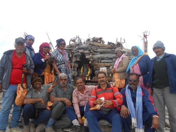
Day 5 – The summit day – Bhagwaabaasa to Roopkund to Junaargali to Pathar Nachauni
The biggest and the most important day of the Roopkund trek, the summit day was here. We knew we had to give it whatever we had. The day began really really early, at 3 am, as Neeraj blew the whistle. All of us got ready in a flash and were all set to trek by 4 am. The best part about today was no backpacks! All we carried was some food, water and warm clothing. By 4:30 am, the trek started. It was dark. So we all carried our own torches, parading one behind the other. It was quite a sight. After a while, it got a little monotonous, so Sandy a.k.a. Sandeep started singing songs. Saranbir and I joined and the fun began. It was a gradual slope to begin with. A sudden steep stretch and then again, the gradual slope upwards. By 6 am, we had done half the ascent. We started seeing boards 2.5 km, 2 km to Roopkund and so on. This pumped us up.
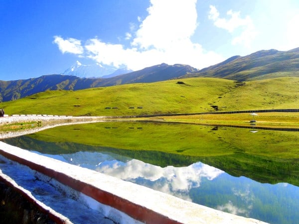
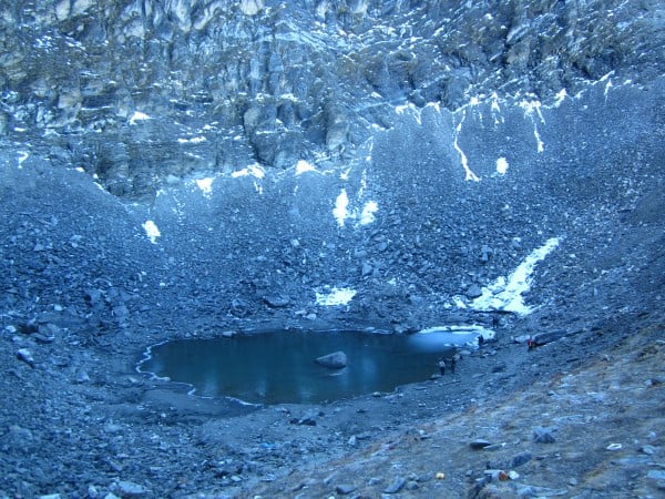
But the ascent got steeper and tougher. We had to give it all we had today. Regular breaks did help rejuvenate stamina. Finally, we saw a board that read .5 km to Roopkund and that gave us the final boost we needed. We increased our pace and finally, we saw the famous Roopkund and heaved a sigh of relief! Our final destination, Junaargali, was little over half an hour from here. The lead insisted on resting here. We got down the slope and started playing with the thin slices of ice, throwing them on the lake. It was a lot of fun.
A photo session later, we started towards the peak, Junaargali. It was just 400 feet but a pretty steep ascent. We made it to our final destination at around 8.40 am. It was an ecstatic feeling to get to the top and enjoy the view of serene snow clad peaks. We had our breakfast and the best photo session thus far. We had done it. 16,000 ft in 4 days. A sense of achievement and relief took over. Soon enough, Saranbir reminded us that trek was just half done. The remaining half was to get down and reach the camp safe and sound. We started our descent by around 10 am. It was steep, so we carefully had to get down. We reached Roopkund in less than 15 minutes. The descent is always faster. A quick rest at the Roopkund Lake and we started our descent towards Bhagwabaasa camp, where we had to have our lunch. We reached the Bhagwabaasa camp by around 12.30 in the afternoon.
We all were a little too tired and it was pretty cold outside. But then, it was not yet over for the day. We had lunch and by 1 pm, we quickly started towards Patar Nachauni, which was our destination for the day. We rested for almost half an hour at Kalu Vinayak Mandir. Then we started towards the base camp, which we kept seeing from a long distance and finally reached by 3.30, before having a good session of omelet at a stall nearby, and we were welcomed with noodles and soup. The big day was over and it was blissful in the camp. Sharing experiences and rejoicing the lighter moments ensued.
Folklore:
Bhagwabaasa: Bhaag (Lion) baasa (Waas – Residence) Literally, it translates to the ‘Residence of the Lion.’ The lion is the vehicle of Goddess Durga. There is a very intriguing cave in Bhagwaabaasa, which is told to be the place where the lion of Goddess Durga rested. Hence, the name.
Roopkund: Goddess Parvathi was traveling in the Himalayas. She had everything she needed, but she was missing a mirror. She asked Lord Shiva for a mirror. Lord Shiva dug the earth with his Trishool and formed a pond. The pond (kund) had such clear water that it reflected just like a mirror. Devi Parvathi could see her beauty (roop) in that pond (kund). Hence, the name Roopkund.
Roopkund
This entry has been shortlisted for Holidify’s Travelogue Writing Contest in association with Linger. The content and pictures may not be used without prior permission of the author.
Submitted by: Keerthy Jagadeesh
The original post can be found here.